
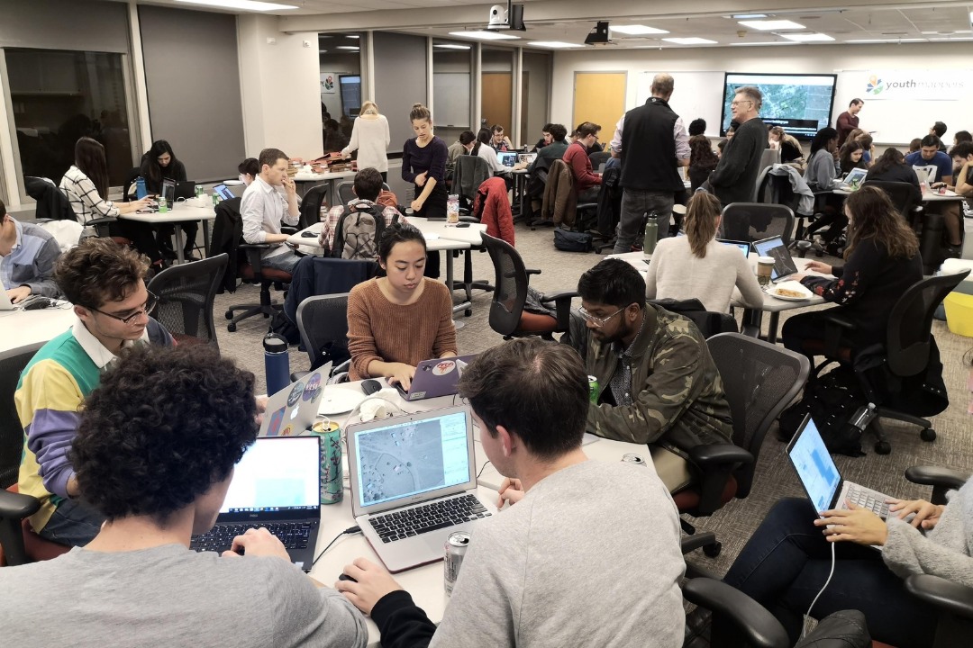
For nearly 10 years, students in the Columbian College Geography Department have played a hands-on role in combatting crises around the world—without ever leaving their laptops.
GW is a founding university in USAID’s YouthMappers network. The university’s student-run chapter—called the Humanitarian Mapping Society at GW (HMSGW)—uses Geographic Information Systems (GIS) technology to chart some of the developing world’s most vulnerable regions in response to threats like epidemics and natural disasters. Along with faculty advisors, HMSGW has partnered with organizations such as the World Bank and the Red Cross. At “Mapathon” gatherings, they’ve provided the data needed to guide ambulances through earthquake-ravaged streets in Nepal, lead rescuers to flood-stranded families in Ghana and coordinate relief responses to mud slides in Sierra Leone.
“We may be sitting at our computers, but we are always aware of the real-life implications of what we are doing,” said HMSGW Vice President Amy MacKinnon, a senior geography and international affairs major. “What we do from our desks impacts people on the ground.”
And now the department and HMSGW are embarking on new initiatives to cultivate the next generation of student mappers and welcome more women into the geospatial community.
The new initiative is titled Everywhere She Maps. This program is funded by a $1.5 million grant through the United States Agency for International Development (USAID) by and for YouthMappers, which is sponsored by the USAID GeoCenter. Through the YouthMappers’ activities, GW will play a key role in efforts to address the underrepresentation of women in the geospatial community. In addition to Everywhere She Maps, YouthMappers will soon launch an online academy where students around the world can hone in-demand GIS skills and contribute to global mapping projects. The GW Geography Department and HMSGW students played a crucial and leading role in the creation of this platform.
“These programs not only provide young people with a foundation in technical skills, but they also offer real leadership training in everything from managing projects to meaningfully participating in global events,” said Michael Mann, an assistant professor of geography and a member of the YouthMappers Steering Committee.
GW is one of three founding universities that partnered with USAID on its initial 2015 YouthMappers network. Since then, the program has grown into a global network of 260 university chapters in more than 57 countries, including under-mapped nations like Tanzania and the Democratic Republic of Congo. GW students “have been at the forefront of the whole YouthMappers concept,” said World Bank consultant Nuala Cowan, who helped create the GW chapter while an assistant professor of geography. The majority of HMSGW students are either majoring or minoring in geography. (Geography offers a GIS minor.)
Student mappers work with a free-mapping platform called OpenStreetMap (OSM) to create data from satellite imagery and geospatial technology. They tag locations on editable maps—labeling, for example, hospitals, collapsed buildings or cleared roads that can be used as emergency management routes. Although in-country mappers verify the information, the OSM open-source platform allows all users to add details to the maps. “It’s critical to get people properly trained because the edits they make go live to the world the minute that they hit a button,” Mann said.
That’s the goal of the online YouthMappers Academy, which will launch in April and will initially be available to all YouthMappers university chapters around the world. Student users access GW geography faculty-written lessons and exercises to perfect their OSM skills. At the end of their training, they receive an American Geographical Society credential called a geobadge. “The academy will teach GIS skills and help students learn how to be good stewards of the data and good community participants within OSM,” said Associate Professor of Geography Ryan Engstrom, who sits on the YouthMappers Steering Committee.
In addition to beta-testing the online academy’s functions, HMSGW students are also part of the YouthMappers Validation Hub, a group of experienced student mappers who safeguard data quality and review maps for errors. “There are a lot of people who come into [YouthMappers] and have zero experience. They’ve never opened up OSM before,” said HMSGW President Natalie O’Dell, a senior geography major who is also minoring in GIS. O’Dell, who trains other students through a YouthMappers internship program, stresses that each piece of data may help humanitarian workers navigating crisis zones or aid organizations distributing medical supplies. “The better information they have, the better they can do their jobs,” she said.
Everywhere She Maps
At the same time, YouthMappers is launching a new initiative called “Everywhere She Maps,” which is designed to increase female participation within the traditionally male-dominated geospatial community while expanding professional opportunities for women.
The program includes leadership forums for women in technology; student ambassadors who recruit other female mappers; and an emphasis on mapping features that are relevant to women such as charting women and family healthcare providers, education services and safety shelters.
HMSGW student mappers will provide training and serve as validators for Everywhere She Maps students. “It’s exciting to help women enter this field,” said O’Dell, who plans to pursue a career in public health and urban planning. “We have a long way to go. I still go to [mapping events] where there are all-male speakers. But I see us narrowing the digital divide. I’m very hopeful about the future of women in mapping.”