
Senior geography major Siri Knudsen has helped combat malaria in Mozambique, mud slides in Sierra Leone and an Ebola outbreak in Guinea. She’s guided ambulances through earthquake-ravaged streets in Nepal and Puerto Rico, and led rescuers to flood-stranded families in Ghana.
And she’s done it all on her laptop from GW’s Foggy Bottom campus.
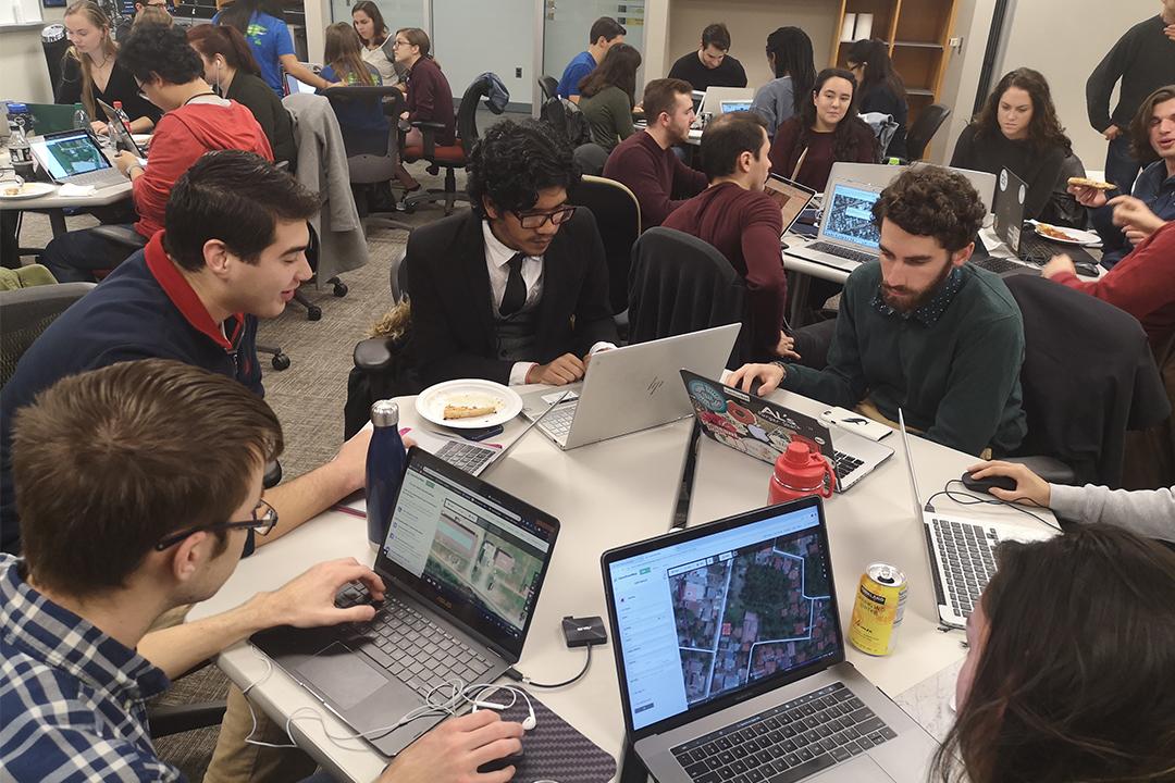
For four years, Knudsen has been a member of the Humanitarian Mapping Society (HMS), a student-run organization within the Department of Geography. The group uses Geographic Information Systems (GIS) technology to map some of the developing world’s most vulnerable regions in response to crises from epidemics to natural disasters. The department and HMS students partner with NGOs, nonprofits and organizations such as the World Bank, the Red Cross and USAID to identify hospitals, roads and emergency management routes from satellite imagery. At “Mapathons,” dozens of students digitally diagram global landscapes to address a dearth of accurate mapping. During this fall’s Geography Awareness Week, more than 70 students mapped 34,000 buildings and nearly 100 miles of roads in the Philippines. They also led the World Bank's flagship Mapathon in outlining flood-vulnerable regions of Ghana.
“Mapathons are one way anyone—students, faculty and the community—can advance the use of open geographic data to empower people to map a more sustainable future,” said Geography Department Chair Lisa Benton-Short. “This is more than just teaching our students; it’s reaching beyond the campus and even the U.S. Experiences such as these can inspire and teach a new geography that could transform peoples lives around the world.”
Mapping Mavericks
GW is one of three founding universities that partnered with USAID on its initial 2015 YouthMappers project. HMS, the GW chapter of that initiative, has helped spearhead student mapping organizations around the world. Today, YouthMappers is a global network of 140 university chapters in more than 40 countries, including under-mapped nations like Botswana and Tanzania. GW students “have been at the forefront of the whole YouthMappers concept,” said Geography Research Professor Nuala Cowan, an HMS faculty adviser and World Bank consultant. The majority of the students participating in the project are either majoring or minoring in geography. (Geography offers a GIS minor.)
“We all talk about wanting to make a difference and this is something I can do from campus that will directly impact people around the world,” Knudsen said. “Even though I’m thousands of miles away, I know that my maps are helping real people on the ground.”
HMS conducts at least one large scale Mapathon on-campus each semester and participates in two or more events organized by the department faculty in collaboration with major aid organizations like USAID. They also hold numerous mini-Mapathons throughout the year for the club’s 30-members. In four years, HMS President Johanna Belanger, a senior majoring in international affairs and minoring in GIS, estimates she’s attended more than two dozen events and mapped hundreds of cities.
“It’s empowering because 10 years ago this wasn’t a thing,” Belanger said. ”Now we can map a Nigerian city from a satellite and then share that information with YouthMappers in Lagos who can finish the work in their hometowns.”
HMS students work with a free-mapping platform called OpenStreetMap (OSM) to collect data points from satellite imagery and geospatial technology. They tag locations on editable maps, labeling, for example, oblong structures that appear to be buildings or long rectangles that looks like roads. “When you are remotely mapping, you don’t have a bird’s eye view, so there is a lot of uncertainty,” Belanger said. “You mark what you think looks like a hospital or school but you don’t know for sure.” In-country mappers verify the information through the OSM open-source platform. Nicknamed the “Wikipedia of Maps,” OSM allows all users to access the GIS data and add details to the maps—a critical factor for humanitarian agencies providing services to poorly-charted regions. “There is little incentive for commercial firms to map some of these areas so they count on OSM,” Cowan said. “It might be the only platform that a poor community has to get themselves literally on the map.”
All students in Geography Department GIS classes attend at least one Mapathon as part of their coursework. But while having a GIS background helps, it’s not required to operate the user-friendly OSM platform. Most Mapathons begin with a 20-minute software tutorial and experienced student mappers are on-hand to answer questions. “Everyone has an ‘ah ha’ moment at their first Mapathon, whether they are international students or literature majors,” Belanger noted. “It sounds hard at first, but at some point the light goes on and they say to themselves, ‘Yeah, I can do this.’” During the GeoWeek Mapathon, which traced secure food routes through the Philippines, students enjoyed free pizza and soda at Gelman Library as they mapped close to 14,000 pieces of infrastructure in under four hours. “This is an incredible amount of work for one project,” Cowan said. “That could be a year of an individual cartographer’s life.”
Still, Knudsen says the students are always aware of the real-life implications of their work. “Our data is important for the who-, the what- and the where-of-mapping,” Knudsen said. In addition to helping humanitarian workers navigate crisis zones, the maps provide population data that aid organizations use to distribute everything from vaccinations and medicines to mosquito nets. “The more information they have the better, they can access it and do their jobs,” she said. A current HMS project with Tanzanian NGOs is helping nonprofits halt female genital mutilation by bringing health services and education to communities where the practice persists.
“Be it for disaster preparedness and response or maybe fighting the spread or prevention of disease, the students recognize the need and now have a way of contributing to make a difference, even though the affected area is on the other side of the world from us,” said Richard Hinton, an HMS adviser and manager of the Geography Department’s Spatial Analysis Laboratory.
Occasionally the student mappers get to see the product of their work first hand. This winter, Belanger will be in Pretoria, South Africa, as a YouthMapper Leadership Fellow to work with GIS professionals and fellow students on introducing geospatial data in local communities. And last year, Knudsen traveled to Botswana with Assistant Professor of Geography Joseph Dymond’s Environment, Economy and Culture class where she and Hinton verified some of the same maps produced at GW Mapathons.
“It’s a very real feeling to walk the streets and visit those communities you saw in map grids and satellite images,” Knudsen said. “It reminds you that even doing something on a small scale can have a big impact in the world.”